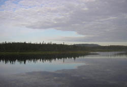
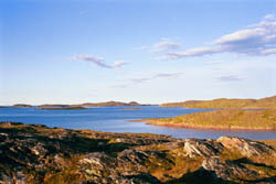
 Labrador,
though the southernmost region geographers consider Arctic, remains very
difficult to access. Pack ice from Baffin Bay and Davis Straits, as well
as towering icebergs spawned by the Greenland Ice Cap, are swept onto
the coast by the Labrador Current, an area known as Iceberg Alley. The
result is that Labrador is much less accessible by sea than western Greenland,
and often even less accessible than Lancaster South, far to the north.
Yet the shortened summer season opens this stunningly beautiful region
to small boats for a few short months each year. The Sailing Directions
for Newfoundland and Labrador indicates that the ice generally does not
clear off southern Labrador until late May or early June, and typically
does not break up in the vicinity of Nain, the northernmost settlement,
until the last week of July.
Labrador,
though the southernmost region geographers consider Arctic, remains very
difficult to access. Pack ice from Baffin Bay and Davis Straits, as well
as towering icebergs spawned by the Greenland Ice Cap, are swept onto
the coast by the Labrador Current, an area known as Iceberg Alley. The
result is that Labrador is much less accessible by sea than western Greenland,
and often even less accessible than Lancaster South, far to the north.
Yet the shortened summer season opens this stunningly beautiful region
to small boats for a few short months each year. The Sailing Directions
for Newfoundland and Labrador indicates that the ice generally does not
clear off southern Labrador until late May or early June, and typically
does not break up in the vicinity of Nain, the northernmost settlement,
until the last week of July.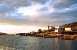
Battle Harbour is the site of the most famous "Outport" in Labrador. Once known unofficially as the "Capitol of Labrador", Battle Harbour was established as a fishing premises in 1775 by the John Slade Company of Poole, England, and became the preeminent center for cod, salmon, and seal fisheries on the Labrador. Through a succession of two more ownerships, the site operated continuously in this trade until the collapse of the cod fishery in 1991, producing millions of tons of salt cod over two hundred twenty years. In 1893 Dr. Wilfred Grenfell established the first Grenfell Hospital which brought health care to Labrador. Battle Harbour was also the venue for most legal and administrative affairs, location of the Marconi wireless station from which was transmitted the news of the press conference in which Peary asserted his claim of attaining the North Pole.
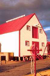 Battle
Harbour has been extensively restored by the Battle Harbour Historic Trust.
Magnificent buildings such as the Grenfell cottage, the Battle Harbor
Inn, and other historic buildings are not only open to the public, but
also available to rent as lodgings for private getaways, family reunions,
or conferences. It remains largely undiscovered because of difficulty
of access, although road and air service are provided to nearby Mary's
Harbour, and water taxi service is available to Battle Harbour. The trust
desperately needs funding to continue its work, and graciously welcomes
yachts as well as lodgers.
Battle
Harbour has been extensively restored by the Battle Harbour Historic Trust.
Magnificent buildings such as the Grenfell cottage, the Battle Harbor
Inn, and other historic buildings are not only open to the public, but
also available to rent as lodgings for private getaways, family reunions,
or conferences. It remains largely undiscovered because of difficulty
of access, although road and air service are provided to nearby Mary's
Harbour, and water taxi service is available to Battle Harbour. The trust
desperately needs funding to continue its work, and graciously welcomes
yachts as well as lodgers.
We make a point to try to stop in Battle Harbour on both legs of the
voyage, usually arriving northbound the first of July, Canada Day. We
enjoy the hospitality here as we steep ourselves in the history and tradition
this site offers us, the same that it gave schooners bound Down the Labrador
for hundreds of seasons before. Often it is necessary to wait out a gale
and to allow sea ice, sometimes just a few days cruise to the north, to
move offshore. 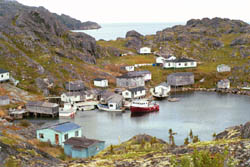
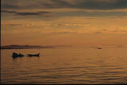
A half's sail to the north of Battle Harbour, Triangle Harbor and Cape Bluff Harbor are just south of Cape Bluff. There was a substantial ocean surge just outside Triangle Harbor as we approached the entrance in 2000, but fortunately, we were greeted by two fishermen who gladly piloted us into the harbor with their dory. The small outport is currently enjoys a thriving local crab fishery, and this small village is alive once again, even though no cod is drying on flakes onshore.
 The
Punchbowl, another abandoned codfish outport, lies just north of Frenchmen's
Run, a spectacular thirty mile long inside passage with, once again, an
extremely narrow entrance into the harbor, though this one is buoyed.
In 2000 a local entrepreneur had taken over the fish plant and was collecting
iceberg ice for sale, but it appeared to be once again abandoned when
we stopped in 2002. By 2004, most of the buildings had been stripped and
dismantled for salvage.
The
Punchbowl, another abandoned codfish outport, lies just north of Frenchmen's
Run, a spectacular thirty mile long inside passage with, once again, an
extremely narrow entrance into the harbor, though this one is buoyed.
In 2000 a local entrepreneur had taken over the fish plant and was collecting
iceberg ice for sale, but it appeared to be once again abandoned when
we stopped in 2002. By 2004, most of the buildings had been stripped and
dismantled for salvage.
Cartwright, named for 18th century merchant, adventurer, and privateer George Cartwright, is now a small fishing port and regional service center for the many small out-ports in the area. A coastal freighter/passenger liner calls here regularly, and an airstrip provides service to Goose Bay, where the old NATO air base now serves as the area's "International Airport". The road from Red Bay to Cartwright was completed in the summer of 2003, opening parts of southern Labrador to vehicles. Randy Cahill, a Newfoundlander, runs a marine services business and has always been very helpful during our visits to Cartwright. In 2000 he was nice enough to loan us charts on areas of the mid-coast of Labrador that we had been unable to purchase while in Halifax.
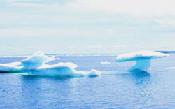
Just north of Cartwright is the Wonder Strand, a 26 mile long sandy beach that was remarkable enough to Leif Erickson that it's referred to in the Icelandic Sagas. This reference was one of the keys to locating the L'Anse aux Meadows site in the early 1960's. The Strand leads to the crossing of Hamilton Inlet, the 140 mile long fjord that serves as the entrance to Goose Bay. This area is swarming with hundreds of common puffins, murres and razorbills flying to and from their rookeries located on offshore outcrops. Icebergs become more common offshore, littering the horizon.
 We
rely greatly on ice reports published by Environment Canada. In 2001 the
ice reports had been sketchy, as a persistent fog and heavy cloud cover
had obscured aerial and satellite observations. The latest reports had
coverage in the vicinity of Cape Harrison as high as eight-tenths pack
ice. The cape is generally the choke-point for late season pack ice driven
onto the coast by the Labrador Current, so we had made our approach to
the cape cautiously. In a place called Smokey Tickle (tickle being the
Labrador expression for a pass, transit of which was always a ticklish
affair in the days of the schooners), is an abandoned wharf. Laying to
the wharf, in addition to Tamara, had been a small coastal freighter
and fishing boat, as well as the bright red 50' aluminum cutter Rosita.
After more than a year's cruise of the North Atlantic, Rosita and
the Moore family would head south for home and school. But the rest of
the little flotilla was north bound and the salient question was, "Where
is the ice?"
We
rely greatly on ice reports published by Environment Canada. In 2001 the
ice reports had been sketchy, as a persistent fog and heavy cloud cover
had obscured aerial and satellite observations. The latest reports had
coverage in the vicinity of Cape Harrison as high as eight-tenths pack
ice. The cape is generally the choke-point for late season pack ice driven
onto the coast by the Labrador Current, so we had made our approach to
the cape cautiously. In a place called Smokey Tickle (tickle being the
Labrador expression for a pass, transit of which was always a ticklish
affair in the days of the schooners), is an abandoned wharf. Laying to
the wharf, in addition to Tamara, had been a small coastal freighter
and fishing boat, as well as the bright red 50' aluminum cutter Rosita.
After more than a year's cruise of the North Atlantic, Rosita and
the Moore family would head south for home and school. But the rest of
the little flotilla was north bound and the salient question was, "Where
is the ice?"
Nothing surpasses local knowledge and an on scene report, so we graciously allowed the freighter and fishing boat to proceed us. A few hours later the freighter's master reported that only numerous large bergs, and their more dangerous spawn, low floating growlers, remained. The pack was gone. Although the thick fog required a very sharp lookout, we were relieved to be clear of the pack, and rounded Cape Harrison. Mark had been in the pack ice a few times before, in the Bering Sea, but even though Tamara is heavily built of steel, we had no intention to purposely put her in the ice.
 In
2002 we held up in Cartwright for five days awaiting favorable ice reports.
The pack ice had come into Hamilton Inlet making our progress north impossible.
Finally we felt that an opportunity had opened up and we departed early
for Smokey Tickle. We sailed a few hours north when we saw the thin white
line on the horizon indicating ice. As we slowly approached the pack we
were forced to looked for a lead closer to shore, eventually making our
way across Hamilton Inlet and the approach leading to Smokey Tickle. But
the pack thickened and we were forced to find an alternative anchorage,
free of ice. We headed up Hamilton Inlet, finding a nice spot we would
normally have passed by on our rush north. This was one of many new anchorages
we would discover the summer of 2002 as the pack ice was persistent along
the coast. After two days of waiting, we left our safe anchorage and proceeded
to Smokey Tickle in clear (relatively speaking) waters.
In
2002 we held up in Cartwright for five days awaiting favorable ice reports.
The pack ice had come into Hamilton Inlet making our progress north impossible.
Finally we felt that an opportunity had opened up and we departed early
for Smokey Tickle. We sailed a few hours north when we saw the thin white
line on the horizon indicating ice. As we slowly approached the pack we
were forced to looked for a lead closer to shore, eventually making our
way across Hamilton Inlet and the approach leading to Smokey Tickle. But
the pack thickened and we were forced to find an alternative anchorage,
free of ice. We headed up Hamilton Inlet, finding a nice spot we would
normally have passed by on our rush north. This was one of many new anchorages
we would discover the summer of 2002 as the pack ice was persistent along
the coast. After two days of waiting, we left our safe anchorage and proceeded
to Smokey Tickle in clear (relatively speaking) waters.