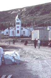
 The
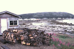
first major village north of Cape Harrison is the predominantly Inuit
community of Makkovik. The people of Makkovik take great pride
in their village, and are exceptionally hospitable and helpful. Here we
take on fuel, water and some stores, as well as go out to the local lodge
for a rare meal off the boat. While in Makkovik in 2001, a Canada Fisheries
and Oceans Officer informed us that he had just received satellite imagery
that showed that the pack ice had cleared off Cape Harrison on July 6th
- we cleared the Cape on July 8th.
The
first major village north of Cape Harrison is the predominantly Inuit
community of Makkovik. The people of Makkovik take great pride
in their village, and are exceptionally hospitable and helpful. Here we
take on fuel, water and some stores, as well as go out to the local lodge
for a rare meal off the boat. While in Makkovik in 2001, a Canada Fisheries
and Oceans Officer informed us that he had just received satellite imagery
that showed that the pack ice had cleared off Cape Harrison on July 6th
- we cleared the Cape on July 8th.
 While
tied up to the wharf at Makkovik, we're able to observe the common docking
procedure of the coastal freighters that serve the Labrador coast. As
large wharves are not feasible due to cost and the remote location, the
ships are instead moored stern-to the wharf, enabling them to lower a
stern ramp for vehicles and roll on/roll off cargo. This maneuver necessitates
dropping anchors off the wharf, pivoting on the chain, and then backing
down until mooring lines can be passed ashore. In the confined harbors,
without bow thrusters or even twin-screw propulsion, this requires an
extraordinary degree of seamanship.
While
tied up to the wharf at Makkovik, we're able to observe the common docking
procedure of the coastal freighters that serve the Labrador coast. As
large wharves are not feasible due to cost and the remote location, the
ships are instead moored stern-to the wharf, enabling them to lower a
stern ramp for vehicles and roll on/roll off cargo. This maneuver necessitates
dropping anchors off the wharf, pivoting on the chain, and then backing
down until mooring lines can be passed ashore. In the confined harbors,
without bow thrusters or even twin-screw propulsion, this requires an
extraordinary degree of seamanship.
 A
day's run from Makkovik, through numerous islands and rock outcrops, lays
Hopedale, a Moravian village established in 1781 by Jens Haven.
Haven, a Dane, was a master carpenter who felt called to the church. Aware
of the tragic attempt by the Moravians to establish a mission near Makkovik
in 1752, Haven studied the native language and customs in Greenland prior
to making reconnaissance voyages to Labrador. This preparation allowed
Haven to avoid the violent confrontation with the Inuit that had scuttled
the 1752 attempt, and enabled the future success of numerous mission sites.
An original mission building remains in Hopedale, and is Canada's oldest
wooden structure east of Quebec. An abandoned Cold War DEW Line radar
site overloooks the village. At one time it housed American soldiers,
and was complete with a bowling alley and movie theater.
A
day's run from Makkovik, through numerous islands and rock outcrops, lays
Hopedale, a Moravian village established in 1781 by Jens Haven.
Haven, a Dane, was a master carpenter who felt called to the church. Aware
of the tragic attempt by the Moravians to establish a mission near Makkovik
in 1752, Haven studied the native language and customs in Greenland prior
to making reconnaissance voyages to Labrador. This preparation allowed
Haven to avoid the violent confrontation with the Inuit that had scuttled
the 1752 attempt, and enabled the future success of numerous mission sites.
An original mission building remains in Hopedale, and is Canada's oldest
wooden structure east of Quebec. An abandoned Cold War DEW Line radar
site overloooks the village. At one time it housed American soldiers,
and was complete with a bowling alley and movie theater.
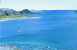
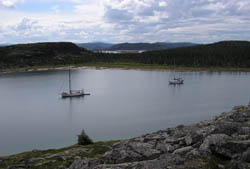 Kangekluktanna Bay, 56º 04' N, 61º
13' W, we call Wooden Shoe Cove. It was recommended to us by a couple
from Portsmouth, NH whom we had met in Cartwright, Summer 2000. They were
returning from several years in Greenland, aboard their husky North Sea
work boat style motor-sailor. Their red Little Bear reminded Mark
of the nursery rhyme, "Winkin, Blinkin and Nod, sailed off in a wooden
shoe", as well as the red wooden shoes his Danish stepmother had
once worn to garden. Unable to pronounce the Inuit name, we simply penciled
that moniker on our chart. Although quite deep, the cove offers good protection
from all but west winds. In 2001 we held up here during 30-35 K easterlies.
Kangekluktanna Bay, 56º 04' N, 61º
13' W, we call Wooden Shoe Cove. It was recommended to us by a couple
from Portsmouth, NH whom we had met in Cartwright, Summer 2000. They were
returning from several years in Greenland, aboard their husky North Sea
work boat style motor-sailor. Their red Little Bear reminded Mark
of the nursery rhyme, "Winkin, Blinkin and Nod, sailed off in a wooden
shoe", as well as the red wooden shoes his Danish stepmother had
once worn to garden. Unable to pronounce the Inuit name, we simply penciled
that moniker on our chart. Although quite deep, the cove offers good protection
from all but west winds. In 2001 we held up here during 30-35 K easterlies.
 The
first successful Moravian mission set up by Haven was at Nain in
1771. The timber-framed buildings were prefabricated in England, and erected
on site by Haven and three other missionaries on land granted by the Crown
of England. The Moravians initiated mission and trading activities in
that year. The Crown facilitated this effort, as it furthered the policy
of precluding intrusion by the French, and was in an area that the Crown
monopoly, the Hudson Bay Company, had ignored. Thus the missions could
bring the influence of the Crown to the region, while costing the exchequer
nothing, as the missions were to be self-supported by trade in fish, fur,
whale oil and baleen.
The
first successful Moravian mission set up by Haven was at Nain in
1771. The timber-framed buildings were prefabricated in England, and erected
on site by Haven and three other missionaries on land granted by the Crown
of England. The Moravians initiated mission and trading activities in
that year. The Crown facilitated this effort, as it furthered the policy
of precluding intrusion by the French, and was in an area that the Crown
monopoly, the Hudson Bay Company, had ignored. Thus the missions could
bring the influence of the Crown to the region, while costing the exchequer
nothing, as the missions were to be self-supported by trade in fish, fur,
whale oil and baleen.
Today, Nain remains the primary center of the Labrador Inuit population,
is the northernmost settlement on The Labrador and serves as a regional
government and service center. It's the last opportunity to top off our
fuel tanks, take on final stores, drop mail and prepare for the spectacular
section of coast that leads to Hudson Strait. The village runs a quarry
mining labradorite, named for the type of feldspar found in the local
anorthosite that surrounds the area. Labradorite can exhibit iridescence,
a brightly colored internal reflection of blue, green, yellow and bronze.
The quarry uses the granitic rock, with its spectacular luminescent blue
crystals, to make 12"x12" floor tiles.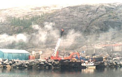
Nick, skipper of Belvedere, had told us of John Hayes Harbor, a half day south of Nain, where labradorite could be picked up along the beaches. On our first visit in 2000 we entered the small opening to the harbour in extraordinarily thick fog with the aid of our radar. The entrance seems only a few meters wide, but with Mark navigating by radar and Nancy on deck trying to see, we inched our way into the entrance. Once inside and anchored, the fog began to lift and we found ourselves in a beautiful small anchorage. The next morning we took the dinghy to the beach, and just as Nick promised, we found crystals of the iridescent blue mineral at the edge of the water.
Nain also marks the tree line. Although isolated forests occur but in a few places beyond Nain, the natural beauty of the region is in no way diminished, as spectacular geology comes to dominate the geography. Caribou, bird rookeries, the beginning of polar bear range, and superb Arctic Char fishing all combine to make one easily forgo trees for a few weeks.
 In
2002 the ice had been persistent along the Northern Labrador coast. Nain
was our last opportunity to get a current ice chart, available from the
Dept. of Fisheries and Oceans. The ice chart showed that there was a large
pack of heavy sea ice moving slowly en masse south and located
at Cape Mugford, 2 days north of Nain, blocking our progress north. A
few days before we arrived, the Nain High School principal reported seeing
lots of ice on the outside of Port Manvers, approximately 40 miles north
of Nain. Not needing to spend time in the village we got out the local
chart and choose an anchorage on the east side of Paul Island. Much to
our delight it turned out to be a beautiful anchorage affording us a vantage
point from which to view the ice pack. Two days later we made our way
up the inside route of Manvers Run and exited Port Manvers in ice free
waters. But as we rounded Cape Kiglaplait, just south of Cape Mugford,
we ran once again into ice. We knew of an anchorage to the west that seemed
like a good place to wait, once again, for the ice. The enforced layover
allowed us to spend two days hiking and exploring an area we may have
otherwise not have cruised.
In
2002 the ice had been persistent along the Northern Labrador coast. Nain
was our last opportunity to get a current ice chart, available from the
Dept. of Fisheries and Oceans. The ice chart showed that there was a large
pack of heavy sea ice moving slowly en masse south and located
at Cape Mugford, 2 days north of Nain, blocking our progress north. A
few days before we arrived, the Nain High School principal reported seeing
lots of ice on the outside of Port Manvers, approximately 40 miles north
of Nain. Not needing to spend time in the village we got out the local
chart and choose an anchorage on the east side of Paul Island. Much to
our delight it turned out to be a beautiful anchorage affording us a vantage
point from which to view the ice pack. Two days later we made our way
up the inside route of Manvers Run and exited Port Manvers in ice free
waters. But as we rounded Cape Kiglaplait, just south of Cape Mugford,
we ran once again into ice. We knew of an anchorage to the west that seemed
like a good place to wait, once again, for the ice. The enforced layover
allowed us to spend two days hiking and exploring an area we may have
otherwise not have cruised.