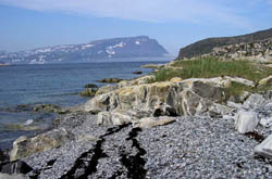
 Cape
Mugford is named after the master of the ship first bringing the Moravians
to the region in 1769. The Cape's striking profile served as the approach
beacon for a long succession of Moravian ships all named "Harmony"
for more than 150 years. The Moravians never lost a ship supplying this
challenging area. The remains of the 1776 mission at Okak and the existing
buildings of the 1829 mission at Hebron, stand as testament to the tenacity,
as well as the craftsmanship, of the Moravians. We anchored in the bay
at Okak in 2000, where only a few foundations and a cemetery remain. Haven
and his fellow missionaries built Okak, the second Moravian mission, in
1776, with the structures having been prefabricated at Nain during the
preceding winter. Its population was tragically devastated by the influenza
epidemic of 1918-19, killing one-third of Inuit along the coast. During
our stay we encountered a native family spending a month close by at their
fish camp. They had come to Okak to pick bake apples, a small orange berry,
common along the Labrador coast, to fish, and prepare for caribou season.
Cape
Mugford is named after the master of the ship first bringing the Moravians
to the region in 1769. The Cape's striking profile served as the approach
beacon for a long succession of Moravian ships all named "Harmony"
for more than 150 years. The Moravians never lost a ship supplying this
challenging area. The remains of the 1776 mission at Okak and the existing
buildings of the 1829 mission at Hebron, stand as testament to the tenacity,
as well as the craftsmanship, of the Moravians. We anchored in the bay
at Okak in 2000, where only a few foundations and a cemetery remain. Haven
and his fellow missionaries built Okak, the second Moravian mission, in
1776, with the structures having been prefabricated at Nain during the
preceding winter. Its population was tragically devastated by the influenza
epidemic of 1918-19, killing one-third of Inuit along the coast. During
our stay we encountered a native family spending a month close by at their
fish camp. They had come to Okak to pick bake apples, a small orange berry,
common along the Labrador coast, to fish, and prepare for caribou season.
Cape Mugford stands out geologically from the rest of northern Labrador. Its rocks were formed by undersea volcanoes in a deep ocean basin and include basalt lava flows, pillow lavas and sedimentary rocks. The result is layered formations that are similar in appearance to that of Southwest US. Most of northern Labrador consists of gneiss, derived mostly from granite, that were deformed and metamorphosed about 2.5 billion years ago. Older bands of gneiss are also found, and at 3.8 billion years of age, are among the oldest on Earth.
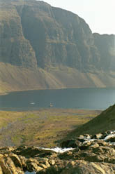
 In
2000, during our 0800 radio schedule with the Belvedere, another
boat broke in after hearing that we would be back in the Mugford area
that night. Chris and Anni Law on Groais II were going into the
inner pool at Anchorstock Bight. We had seen this magnificent harbor on
our way north, but saw no safe way to enter. We arranged to meet them
that evening and try to follow them into the pool. After a brief introduction,
with Chris in the spreaders of their boat and Anni at the helm, we followed
them into the pool. Groais II made it through the extremely narrow
and shallow entrance with apparent ease, but just as we passed the large
rock in the middle of the entrance we hit bottom. Tamara lurched,
the sound of her steel hull hitting rock quite loud, and the look on Mark's
whitened face was one of shock. But that's why he always insisted on a
steel yacht, as years of Alaskan experience and a strong desire to push
into remote places taught that lesson well. An underwater inspection the
next day about froze his face and ears, but convinced him that there was
no real damage, only to paint and pride.
In
2000, during our 0800 radio schedule with the Belvedere, another
boat broke in after hearing that we would be back in the Mugford area
that night. Chris and Anni Law on Groais II were going into the
inner pool at Anchorstock Bight. We had seen this magnificent harbor on
our way north, but saw no safe way to enter. We arranged to meet them
that evening and try to follow them into the pool. After a brief introduction,
with Chris in the spreaders of their boat and Anni at the helm, we followed
them into the pool. Groais II made it through the extremely narrow
and shallow entrance with apparent ease, but just as we passed the large
rock in the middle of the entrance we hit bottom. Tamara lurched,
the sound of her steel hull hitting rock quite loud, and the look on Mark's
whitened face was one of shock. But that's why he always insisted on a
steel yacht, as years of Alaskan experience and a strong desire to push
into remote places taught that lesson well. An underwater inspection the
next day about froze his face and ears, but convinced him that there was
no real damage, only to paint and pride.
Chris and Anni had us over for dinner that evening to enjoy their delicious caribou stew. Knowing that it was not caribou season, we were inquisitive as to the source of the succulent fresh meat. Apparently Chris had been on a hike the day before and had come onto a recently deceased caribou that had been mauled by a polar bear. Being fleet of foot as is characteristic of its species, it had escaped the bear, only to succumb as Chris arrived. He decided that it would be a waste to leave the meat, so butchered the carcass and returned to the boat with fifty pounds of meat wrapped in his T-shirt! After an entertaining evening on Groais II we decided to stay, enjoy the company and explore the area. The next day we hiked with Chris and Anni up to the snowfields so Chris could get photos and movies of himself telemark skiing in Labrador! Who are these people? Chris, who is from England and a dentist, and Anni a Canadian doctor, live in St. Ann's Bay, Cape Breton and have been cruising Labrador for 20 years. In addition, they run a cross-country ski resort, Tuonela, on their property during the winter. We left the following day and managed to just tap the rock on our way out.
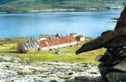 North
of Cape Mugford, the Moravian mission site at Hebron is still largely
intact and is protected as a Canadian National Historic Site. Remains
of the original timber framed structure, prefabricated in England in 1829,
and the church and school dating from 1833 remain as testament to the
piety, as well as the craftsmanship, of the Moravians. Abandoned in 1959,
the Hebron site served as a school for Inuit children and trading post
for 130 years. While we are not pious sorts, these structures, in this
incredibly remote and challenging location, inspire awe. Unlike some other
denominations' efforts, the Moravians are still very much beloved by most
Labrador Inuit. Their schools taught with bilingual instructional methods
two hundred years before most used the term, and traditional native foods,
in respect of their culture, were served the resident Inuit students.
Forty years after the closing of the Hebron mission, it is still very
much missed by many, and resentment remains that the government did not
see fit to continue funding the mission school after the Moravians were
unable to do so. Occasional "Come Home" gatherings are held
at Hebron with the reverence of a pilgrimage. The Moravians succeeded
where others failed primarily because their preeminent emissary, Jens
Haven, took the trouble to study the language before attempting to establish
missions. In later years the Moravians did similar work in western Alaska,
including compiling a complete lexicon of the Yupik Eskimo language.
North
of Cape Mugford, the Moravian mission site at Hebron is still largely
intact and is protected as a Canadian National Historic Site. Remains
of the original timber framed structure, prefabricated in England in 1829,
and the church and school dating from 1833 remain as testament to the
piety, as well as the craftsmanship, of the Moravians. Abandoned in 1959,
the Hebron site served as a school for Inuit children and trading post
for 130 years. While we are not pious sorts, these structures, in this
incredibly remote and challenging location, inspire awe. Unlike some other
denominations' efforts, the Moravians are still very much beloved by most
Labrador Inuit. Their schools taught with bilingual instructional methods
two hundred years before most used the term, and traditional native foods,
in respect of their culture, were served the resident Inuit students.
Forty years after the closing of the Hebron mission, it is still very
much missed by many, and resentment remains that the government did not
see fit to continue funding the mission school after the Moravians were
unable to do so. Occasional "Come Home" gatherings are held
at Hebron with the reverence of a pilgrimage. The Moravians succeeded
where others failed primarily because their preeminent emissary, Jens
Haven, took the trouble to study the language before attempting to establish
missions. In later years the Moravians did similar work in western Alaska,
including compiling a complete lexicon of the Yupik Eskimo language.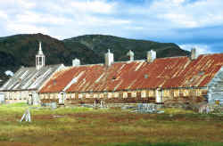
Labrador has been glaciated several times in the last 2.5 million years, as evidenced by its spectacular U-shaped valleys and fjords. The great weight of the ice depressed the landmass into the upper mantle. As the ice melted large parts of the present coastline were covered by the sea. Over time a combination of the land rebounding and the sea level falling has formed raised beaches, an ancient beach that is located above the present shoreline.
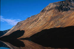 The
coast north of Cape Mugford, paralleled by the Torngat Mountains rising
to over 3,600 feet, is more rugged and mountainous. The coastline is indented
by three large fjords and numerous small inlets and bays. Cape Uivuk towers
over the southeast entrance to Saglek Fjord and houses a radar station,
it's dome visible for miles. Saglek Bay is 14.5 miles wide at the entrance
and extends west for 12 miles before narrowing into Saglek Fjord which
divides into two arms. In 2000 we anchored St. John's Harbour three miles
west of Cape Uivuk but in 2002 and 2004, we sailed up the uncharted North
Arm, anchoring at the head.
The
coast north of Cape Mugford, paralleled by the Torngat Mountains rising
to over 3,600 feet, is more rugged and mountainous. The coastline is indented
by three large fjords and numerous small inlets and bays. Cape Uivuk towers
over the southeast entrance to Saglek Fjord and houses a radar station,
it's dome visible for miles. Saglek Bay is 14.5 miles wide at the entrance
and extends west for 12 miles before narrowing into Saglek Fjord which
divides into two arms. In 2000 we anchored St. John's Harbour three miles
west of Cape Uivuk but in 2002 and 2004, we sailed up the uncharted North
Arm, anchoring at the head.
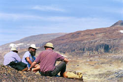
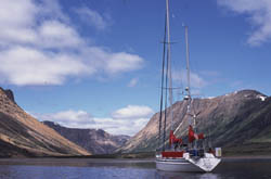 Ramah,
situated well up a spectacular fjord, was of interest to us for a different
reason. While once a mission site as well, there are only rudimentary
foundations remaining. In addition to the scenery, our interest was geologic
and anthropologic. Nancy is trained as a geologist, and both of us enjoy
an amateur's interest in the history of Native Americans. The two interests
are united by a particularly fine-grained, hard, sedimentary rock composed
predominantly of silica, known as Ramah chert. Chert has the property
of fracturing conchoidaly, much like glass, and was the preferred material
for stone-age tools. Ramah chert is of the highest quality, was used by
numerous native groups for thousands of years, and found its way thousands
of miles south via trade.
Ramah,
situated well up a spectacular fjord, was of interest to us for a different
reason. While once a mission site as well, there are only rudimentary
foundations remaining. In addition to the scenery, our interest was geologic
and anthropologic. Nancy is trained as a geologist, and both of us enjoy
an amateur's interest in the history of Native Americans. The two interests
are united by a particularly fine-grained, hard, sedimentary rock composed
predominantly of silica, known as Ramah chert. Chert has the property
of fracturing conchoidaly, much like glass, and was the preferred material
for stone-age tools. Ramah chert is of the highest quality, was used by
numerous native groups for thousands of years, and found its way thousands
of miles south via trade.