|
 This
section would be my last PCT hike in Southern California and the
last I would be able to complete in the spring. I had read several
accounts of this section from hikers I had met over the last 3 years,
and my expectations for this particular section of the trail were
not very high. Hot, very windy, and long stretches between water
sources best described what was ahead. I would be crossing the Mojave
Desert with temperatures possible in the 90º +, 2 long stretches,
36 miles and 31 miles, between water sources, which meant carrying
6 quarts of water for each. Some hikers carried 8 quarts or more
of water, but I couldn't physically carry that much. This
section would be my last PCT hike in Southern California and the
last I would be able to complete in the spring. I had read several
accounts of this section from hikers I had met over the last 3 years,
and my expectations for this particular section of the trail were
not very high. Hot, very windy, and long stretches between water
sources best described what was ahead. I would be crossing the Mojave
Desert with temperatures possible in the 90º +, 2 long stretches,
36 miles and 31 miles, between water sources, which meant carrying
6 quarts of water for each. Some hikers carried 8 quarts or more
of water, but I couldn't physically carry that much.
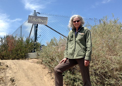
The hike would begin at Hiker Town where I had
ended last April, cross the Mojave Desert floor to the southern
slope of the Tehachapi Mountains, through Tehachapi Pass and Walker
Pass, then into the Southern Sierras, terminating at Kennedy Meadows,
the beginning of the Sierra section.
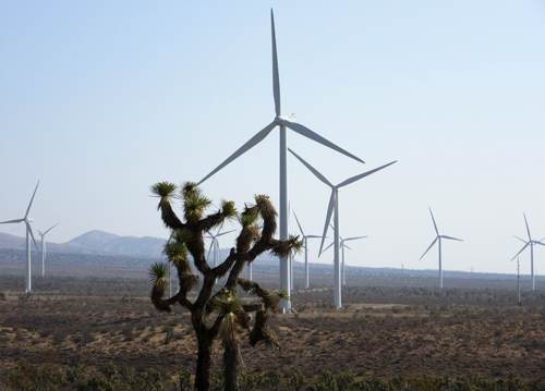 The
Tehachapi Pass is one of the largest wind farm areas in California.
For the first 63 miles a wind turbine was almost never out of site,
whether hiking directly next to it or off in the distance. Tehachapi
Pass Wind Farm, begun in the early 1980s, was one of the first large
scale wind farms installed in the U.S. With over 5,000 wind turbines
it is considered the 2nd largest wind resource area of California. The
Tehachapi Pass is one of the largest wind farm areas in California.
For the first 63 miles a wind turbine was almost never out of site,
whether hiking directly next to it or off in the distance. Tehachapi
Pass Wind Farm, begun in the early 1980s, was one of the first large
scale wind farms installed in the U.S. With over 5,000 wind turbines
it is considered the 2nd largest wind resource area of California.
Tehachapi Pass is a principal connector between
the San Joaquin Valley and the Mojave Desert. The Native American
Kitanemuk people used the pass as a trade route before the region
was settled by whites in the 1800s.
 The
weather reports prior to departure were for cooler than average
temperatures and a chance of thundershowers for the first few days.
Thunderclouds formed in the afternoon on the first day but the rain
was concentrated in the mountains to the north. The afternoon of
the second day thunderclouds began to form with brief periods of
light rain showers becoming heavy in the early evening. Mid-day
on day three the sky grew very dark, with thunder booming louder,
rain being imminent. By 1:00 pm the skies opened up and it began
to pour, then hail. I waited for the precipitation to subside, and
then continued on, skirting showers and hail for the rest of the
afternoon. By late afternoon the skies cleared enough for a view
of the mountains, revealing snow at the higher elevations. By the
time I had made camp that evening the rain had passed and would
not return the remainder of the hike. The passing storms kept the
temperatures in the 70's and 80's. The
weather reports prior to departure were for cooler than average
temperatures and a chance of thundershowers for the first few days.
Thunderclouds formed in the afternoon on the first day but the rain
was concentrated in the mountains to the north. The afternoon of
the second day thunderclouds began to form with brief periods of
light rain showers becoming heavy in the early evening. Mid-day
on day three the sky grew very dark, with thunder booming louder,
rain being imminent. By 1:00 pm the skies opened up and it began
to pour, then hail. I waited for the precipitation to subside, and
then continued on, skirting showers and hail for the rest of the
afternoon. By late afternoon the skies cleared enough for a view
of the mountains, revealing snow at the higher elevations. By the
time I had made camp that evening the rain had passed and would
not return the remainder of the hike. The passing storms kept the
temperatures in the 70's and 80's.
The trail journals I had read described the trail
out of Tehachapi Pass to be very windy, hence all the wind farms.
The trail climbs an exposed ridge as it leaves the pass and as a
front came through I had to be extremely careful not to get blown
over. I kept remembering what a woman from Newfoundland, whom I
had met in the Goat Rocks of Washington, told me. That day on the
trail had been very windy and the visibility poor, but many hikers
were carrying on, anxious to get to White Pass and their next re-supply.
I had taken the day off and talked with hikers as they passed by.
When I encountered the woman from Newfoundland and asked how the
trail was, she said, "I'm from Newfoundland where it's windy
and rainy all the time." Her strategy for dealing with the
high wind was to keep her profile as small as possible and, when
she came to an exposed ridge, hunker down, wait for a break in the
wind, then "go like hell". As I climbed the ridge, with
the wind trying to knock me off my feet, I kept telling myself,
"hunker down and go like hell". The facts that my pack
weighed 40 lbs. and I was using hiking poles also helped keep me
from being bowled over.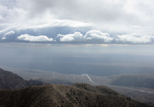
In years past, early hikers would start from the
Mexican border the first of April. The drought of the last few years
in California has many water sources drying up earlier and more
hikers starting in March. Since I was starting April 21st, 519 miles
into the trail, I was expecting to encounter few hikers, and when
I did it would be those who had started in March.
I encountered my first hiker on day 2, a 53 year
old airline pilot from Toronto, who's trail name was "Uncle
Bob". We hiked together for a couple of hours then parted ways
as he took off ahead of me. I wouldn't encounter another hiker for
another 3 days, a young man hiking southbound out of Walker Pass,
and then another 4 days before I saw another hiker. I knew after
a week that there should be a wave of early hikers coming up behind
me, but it wasn't for another week before they finally caught me.
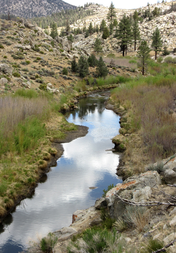
 The
section between Tehachapi and Walker Passes is one of the driest
on the whole PCT. The most I could carry was 6 quarts of water and
I had planned using only 2 quarts a day. The cooler weather was
a help. The first dry stretch was 36 miles between water sources
due to an important spring, Golden Oaks, having been damaged by
animals. After carrying the 6 quarts of water up 2,000 feet along
an exposed ridge in high winds, I came upon Golden Oaks Spring and
found a PCT maintenance crew, all seniors, repairing the spring.
Due to their efforts, the water was now flowing again, so I topped
up one of my bottles and continued on my way. Word would pass quickly
to those behind me that instead of 36 miles it would now only be
17 miles out of Tehachapi before the first water. The
section between Tehachapi and Walker Passes is one of the driest
on the whole PCT. The most I could carry was 6 quarts of water and
I had planned using only 2 quarts a day. The cooler weather was
a help. The first dry stretch was 36 miles between water sources
due to an important spring, Golden Oaks, having been damaged by
animals. After carrying the 6 quarts of water up 2,000 feet along
an exposed ridge in high winds, I came upon Golden Oaks Spring and
found a PCT maintenance crew, all seniors, repairing the spring.
Due to their efforts, the water was now flowing again, so I topped
up one of my bottles and continued on my way. Word would pass quickly
to those behind me that instead of 36 miles it would now only be
17 miles out of Tehachapi before the first water.
Locals leave water caches at strategic points
along the trail in these very dry sections. Hikers are told not
to depend on these caches as they may not be regularly maintained.
Luckily two important caches were stocked, allowing me to add to
my allotted two quarts a day, and giving me a more comfortable margin.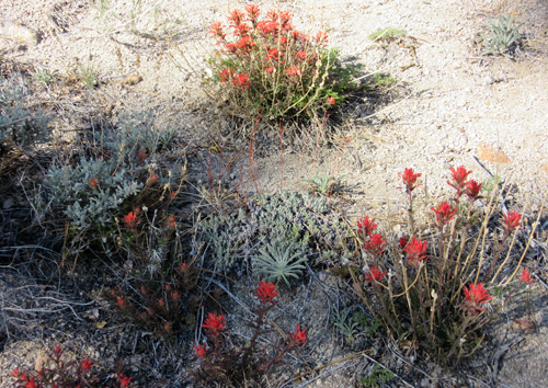
I was really enjoying this time on my own. I seemed
to be in a lull between groups of hikers and would walk along all
day totally into my own thoughts. The complete silence that I experienced
many nights and early mornings was welcomed. Some mornings there
was complete silence, not even the breath of a breeze. I would wake
up before sunrise and just sit, listen and wait for the day to begin.
The few storms that had passed through the area
left enough moisture for the wildflowers to be out in full display.
Every day brought a new display of different types and colors of
flowers lining the trail. This stretch of trail that many hikers
dreaded was for me becoming very fulfilling. I had expected the
worst, but instead I was thoroughly enjoying each day.
 As
I left Walker Pass on day 10 and signed into the trail registry,
I noticed that 3 hikers had signed in that morning. I was finally
becoming part of a wave of hikers on their way to Kennedy Meadows,
the last re-supply point before entering the Sierras. The next day
I began encountering more hikers, as the group behind me finally
caught up. The next three days I would be among about 15 hikers,
all making our way to Kennedy Meadows. For me this would be the
end of this section hike, but for the thru-hikers a place to re-supply
and check on snow and pass conditions before starting into the Sierras. As
I left Walker Pass on day 10 and signed into the trail registry,
I noticed that 3 hikers had signed in that morning. I was finally
becoming part of a wave of hikers on their way to Kennedy Meadows,
the last re-supply point before entering the Sierras. The next day
I began encountering more hikers, as the group behind me finally
caught up. The next three days I would be among about 15 hikers,
all making our way to Kennedy Meadows. For me this would be the
end of this section hike, but for the thru-hikers a place to re-supply
and check on snow and pass conditions before starting into the Sierras.
Once again my brother Dave offered to help and
drove with wife Cyndi from Paso Robles to Kennedy Meadows, over
250 miles one way, to drive me to Lancaster where I would spend
the time before getting transportation into Burbank for my flight
home. Luckily they both love to drive. I had met a young woman on
the trail from Germany who needed to get to Bakersfield. She would
be ending her hike in Kennedy Meadows the same time as I. And an
older man, Robin, was also looking for a ride to Lancaster. When
my brother showed up I asked if he could give two more hikers a
ride, and though at first a little taken aback, he happily took
everyone aboard.
The young German woman, who's trail name was Poncho,
was so charming that my brother called a friend in Bakersfield to
take her in for the night. She was picking up a car she had left
in Bakersfield, and once she was on the road she stayed with Dave
and Cyndi in Paso Robles. I bought Dave a PCT t-shirt making him
now an official Trail Angel.
Once again it's due to the kindness of others
that my hike was a success. I had to hitch-hike into my two re-supply
points, Tehachapi and Onyx, and the drivers were willing to go out
of their way to get me where I needed to go. Thank you!
In prior years I my birthday came after I got
off the trail. But on this section I actually celebrated my 66th
birthday while on the trail. Kind of special.
|
