|
 I
consider myself lucky that in the six years I've been hiking the
PCT I have not had to divert off the trail due to fires. The section
I had planned to hike in September was from Ashland, OR to Burney
Falls, CA, a total of 300 miles. I had been checking the PCT web
site for possible fire closures and, a month before my start, the
trail near Etna was looking dicey due to the Wallow Fire. Then the
week before I was to take off there were two closures: the Wallow
Fire near Etna and the Cook and Abney Fire north of Seiad. I needed
to formulate a backup plan. I
consider myself lucky that in the six years I've been hiking the
PCT I have not had to divert off the trail due to fires. The section
I had planned to hike in September was from Ashland, OR to Burney
Falls, CA, a total of 300 miles. I had been checking the PCT web
site for possible fire closures and, a month before my start, the
trail near Etna was looking dicey due to the Wallow Fire. Then the
week before I was to take off there were two closures: the Wallow
Fire near Etna and the Cook and Abney Fire north of Seiad. I needed
to formulate a backup plan.
I only had 920 miles remaining of the approximately
2,660 total trail distance to finish the complete trail, so my options
were limited: (1) Donner Pass to Burney Falls, 2) Burney Falls to
Ashland, and 3) White Pass to the Canadian Border, which I wanted
to save for the grand finale. The first 90 miles of Option 3 out
of White Pass was closed due to the Mt. Rainier fire. So the only
choice left was to hike from Castle Crags, CA to Donner Pass, a
total of 330 miles.
We had spent the summer cruising our boat in Prince
William Sound, AK, followed by a remote Yukon Territory canoe trip
in late August and early September. September 15th was my self-imposed
deadline to start the hike, as I was anxious not to be caught in
an early snow storm. As soon as we finished the canoe trip we wasted
no time driving south. We arrived in Port Townsend on September
9th, new maps were printed, the trail food reorganized and within
24 hours we were ready to head south to the Castle Crags/Dunsmuir
area of northern California. I began my hike on September 12th.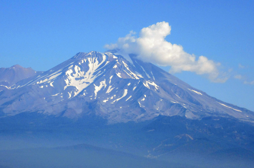
Unlike my previous hikes, Mark was going to support
me on this one. I had worked out various rendezvous points to pick
up resupplies, get a hot meal, then continue on. He would be camping
as he waited for me at prearranged spots, except for the one motel
planned about midway. The change in the section due to fires meant
finding him new camp spots and rendezvous points. The tricky part
was finding campgrounds that would be open past September 15th.
I was surprised the first day out when I ran into
a thru-hiker north bound. He mentioned that I would encounter five
more people, all thru-hikers, not far behind him. It seemed quite
late to be heading north and to have not yet reached Oregon. What
I was to learn was that they were all ending their thru hikes at
Castle Crags. With the two fires between Castle Crags and the CA/OR
border, the numerous fires in Oregon, the Mt. Rainier fire, and
the detours involved in getting around each fire, reaching the Canadian
Border before snowfall was out of reach. I really felt bad for all
of them.
 It
is 82 miles from Castle Crags to Burney Falls and the trail is mostly
through forest just south of Mt. Shasta. The first two nights I
could hear thunderstorms nearby, but luckily it rained very little
on the tent. Mark, who was camped 50 miles NE, had thunder, hail
and rain. Location, location. The temperatures were in the 80's
during the day and 50's at night, very pleasant compared to summertime
when the days can get into the 100's. The most annoying aspect of
the trail was the gnats that swarmed round your head in the hundreds,
getting in your nose, mouth and ears. Oddly enough, if you stopped
for longer than a few minutes they seemed to disappear until you
starting hiking again. Two girls I met along the way had purchased
head nets after battling the pesky flyers for weeks. The only other
people I ran into were sport fishermen on the McCloud River. It
is 82 miles from Castle Crags to Burney Falls and the trail is mostly
through forest just south of Mt. Shasta. The first two nights I
could hear thunderstorms nearby, but luckily it rained very little
on the tent. Mark, who was camped 50 miles NE, had thunder, hail
and rain. Location, location. The temperatures were in the 80's
during the day and 50's at night, very pleasant compared to summertime
when the days can get into the 100's. The most annoying aspect of
the trail was the gnats that swarmed round your head in the hundreds,
getting in your nose, mouth and ears. Oddly enough, if you stopped
for longer than a few minutes they seemed to disappear until you
starting hiking again. Two girls I met along the way had purchased
head nets after battling the pesky flyers for weeks. The only other
people I ran into were sport fishermen on the McCloud River.
 The
two girls told me that in a few days I would see signs of bear and
cougar. In the over 1,900 miles I had hiked so far I had one bear
encounter and maybe saw cougar prints. So I was on high alert as
I approached the area in question. I started seeing bear scat and
at one spot thought I saw cougar scat. As I continued on, the bear
scat began to become more frequent and larger, and at one water
spot there were paw prints. I remembered an interview I had heard
recently how during the fall bears were stressed in the attempt
to put on as much weight as possible before winter. I became especially
anxious when the trail tunneled through thick brush. I would talk
loudly, my favorite reciting the story of Goldie Locks and the Three
Bears. The
two girls told me that in a few days I would see signs of bear and
cougar. In the over 1,900 miles I had hiked so far I had one bear
encounter and maybe saw cougar prints. So I was on high alert as
I approached the area in question. I started seeing bear scat and
at one spot thought I saw cougar scat. As I continued on, the bear
scat began to become more frequent and larger, and at one water
spot there were paw prints. I remembered an interview I had heard
recently how during the fall bears were stressed in the attempt
to put on as much weight as possible before winter. I became especially
anxious when the trail tunneled through thick brush. I would talk
loudly, my favorite reciting the story of Goldie Locks and the Three
Bears.
 I
met up with Mark on day six at Burney Falls and we went into the
town of Burney for a motel, shower, laundry, a big dinner and breakfast.
I was off the next day and would meet up with him in three days
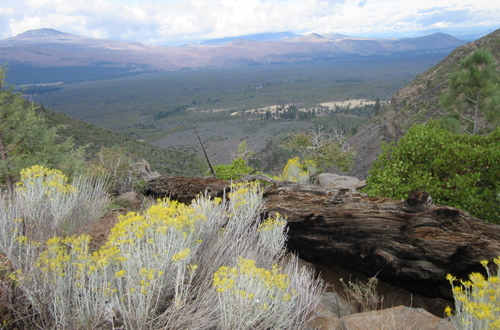
at Old Station. The main feature of this 40 miles of trail is the
Hat Creek Valley and the Hat Creek Rim, a lava plateau. The Trail
follows the rim overlooking the valley and views of Mt. Lassen all
the way to Old Station. The wind whips up the side of the plateau
but 20 feet from the edge it's relatively calm, as the wind continues
steeply upward. Once on the rim it's a 30 miles stretch of trail
with no available water. I learned from another hiker that a water
tank at midpoint was being kept filled for hikers. To my despair,
the directions I was given were incorrect and when I got to the
spot I couldn't find the tank. Fortunately, an Hispanic ranch hand
drove by and when I flagged him down to ask about the water tank,
he gave me several bottles of water, which was all I needed until
Old Station. I
met up with Mark on day six at Burney Falls and we went into the
town of Burney for a motel, shower, laundry, a big dinner and breakfast.
I was off the next day and would meet up with him in three days
at Old Station. The main feature of this 40 miles of trail is the
Hat Creek Valley and the Hat Creek Rim, a lava plateau. The Trail
follows the rim overlooking the valley and views of Mt. Lassen all
the way to Old Station. The wind whips up the side of the plateau
but 20 feet from the edge it's relatively calm, as the wind continues
steeply upward. Once on the rim it's a 30 miles stretch of trail
with no available water. I learned from another hiker that a water
tank at midpoint was being kept filled for hikers. To my despair,
the directions I was given were incorrect and when I got to the
spot I couldn't find the tank. Fortunately, an Hispanic ranch hand
drove by and when I flagged him down to ask about the water tank,
he gave me several bottles of water, which was all I needed until
Old Station.
I met up with Mark at
the Hat Creek Rim Viewpoint, two miles outside Old Station. About
an hour before our rendezvous, I encountered a young woman, Jane,
who I had met a few days earlier. It had started to rain just as
we reached Mark, so I invited her to join us at Mark's camp where
he made us both a good hot dinner. The next morning we all went
to JJ's Cafe for breakfast, after which Jane continued on the trail.
I decided to take the day off since the nighttime temps were dropping
into the 20's, and I had plenty of time to get to Donner Pass.
The only location in the area one could get a
cellphone signal was up at the overlook where I had met Mark the
day before. I had been keeping in touch with my 97 year old mom,
who was having some health issues. That morning there was a voice
message from my sister-in-law saying that, if possible, I should
come visit my mom in Southern California, who seemed to have taken
a turn for the worse. We packed up the camp and began the drive
south. I arrived on Saturday, September 23rd, and she passed away
a week later on September 30th. If I had not stopped for the day
and kept hiking I might not have been able to help her make her
final journey.
 After
12 days off the trail, and watching my mom die, I was ready to get
back on the trail. Mark needed to be in San Francisco on October
12th for a meeting of the Safety at Sea and Seamanship committee
of an international sailing association, and it was apparent that
the time off the trail would now make getting all the way to Donner
Pass impossible. I picked up the trail at Old Station and continued
south through Lassen NP, to meet up with Mark on Hwy 36. The nights
were getting colder. My first night back on the trail, I camped
at 7,000 ft. and the temperature that night dropped to the mid-20's,
though I stayed warm in my bag and tent. The next day I met a couple
day hiking out of Warner Valley Ranch and the day after a young
woman, Chelsea, hiking her first PCT section from Belden to Burney
Falls. Otherwise I was completely on my own. After
12 days off the trail, and watching my mom die, I was ready to get
back on the trail. Mark needed to be in San Francisco on October
12th for a meeting of the Safety at Sea and Seamanship committee
of an international sailing association, and it was apparent that
the time off the trail would now make getting all the way to Donner
Pass impossible. I picked up the trail at Old Station and continued
south through Lassen NP, to meet up with Mark on Hwy 36. The nights
were getting colder. My first night back on the trail, I camped
at 7,000 ft. and the temperature that night dropped to the mid-20's,
though I stayed warm in my bag and tent. The next day I met a couple
day hiking out of Warner Valley Ranch and the day after a young
woman, Chelsea, hiking her first PCT section from Belden to Burney
Falls. Otherwise I was completely on my own.
Mark was waiting on Hwy 36 as planned and we drove
to Quincy for a motel. With only 6 days before I needed to get off
the trail I needed to make some strategic decisions. My hope is
to finish the gaps in the trail between Donner Pass and Ashland
next year. Figuring out the best place to get on and off the trail,
where transportation is available, is always tricky. Chelsea, who
I met that morning, had given me her e-mail address and said that
if I needed help in the future to contact her. All this was swirling
around in my head that night. The next morning I had decided to
only do another 33 miles of trail between Bucks Lake and the Quincy-La
Porte road.
We went to Bucks Lake to camp only to find that
it was hunting season and the area was thick with weekend hunters.
I had bought a bright orange rain cover for my pack which quickly
became my warning to hunters. In the morning as I left Bucks Lake
the wind had begun to blow and got stronger throughout the day.
The forest floor was very dry, the trail crackling under my feet
as I walked, and the environment ripe for a fire. I picked a camping
spot that night in the woods, out of the stronger winds, but I was
alert for any signs of a fire. Occasionally during the night the
tent would be pelted by clouds of pine needles shaken from the trees
by the blasts of wind.
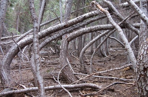
 The
next day the trail was littered with downed branches, but the wind
had abated slightly. I kept scanning the horizon for any signs of
smoke. I was also concerned about hunters since it was the middle
of hunting season. The only person I met along this portion of trail
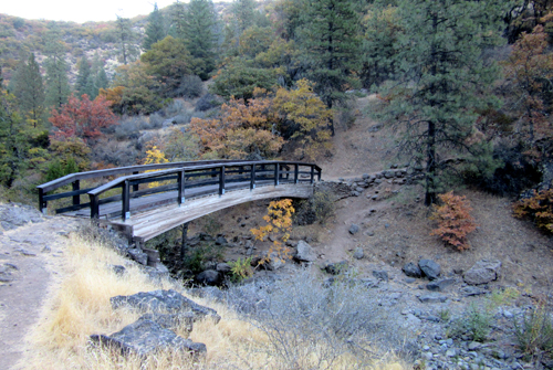
was a PCT hiker at the bridge crossing the Middle Fork Feather River.
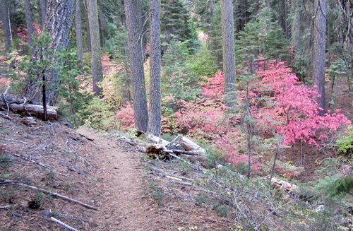
The woods were showing signs of fall as the leaves on the deciduous
trees were turning red. The
next day the trail was littered with downed branches, but the wind
had abated slightly. I kept scanning the horizon for any signs of
smoke. I was also concerned about hunters since it was the middle
of hunting season. The only person I met along this portion of trail
was a PCT hiker at the bridge crossing the Middle Fork Feather River.
The woods were showing signs of fall as the leaves on the deciduous
trees were turning red.
In the morning I hiked as fast as I could, wanting
to meet Mark by our designated time. As I approached the car he
immediately asked if I got his phone message. There was a fire a
few miles to the west and he had called to suggest that I to try
to hike out the night before. No, I had no cell coverage and I had
not seen or smelled smoke all day. It was 2 nights before that the
fires in Santa Rosa had destroyed hundreds of homes. Fires had also
sprung up at Oroville Dam and Brownsville, west of the trail. It
seemed like a good time to get off the trail!
I now have 717 miles left to complete the entire
PCT. My hope is that next year I will finish Northern California,
leaving 350 miles of Washington to finish. It would be nice if it's
a low fire season, but the way the last 4 years have gone ...
This portion of the trail is dedicated to my mom:
|