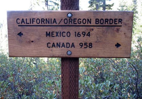
|
I began this journey in April 2014, and I was
about to start my last section. I had been trying to complete this
particular section in 2017 and 2018, but portions of the trail were
closed due to fires. As I started out there was a fire in the Marble
Mountain Wilderness, but the trail was not closed.
 Mark
dropped my off at the trail-head as it emerges from under I-5 at
Highway mile six heading south. It's 8.5 miles up to the Mt. Ashland
Ski area, and Mark would set up camp at a FS campground, just off
the PCT. I slack packed (went with only a day pack) up the trail
to where he was camped, arriving around 1:00 pm on a Friday afternoon.
As the evening progressed, cars and trucks arrived with mountain
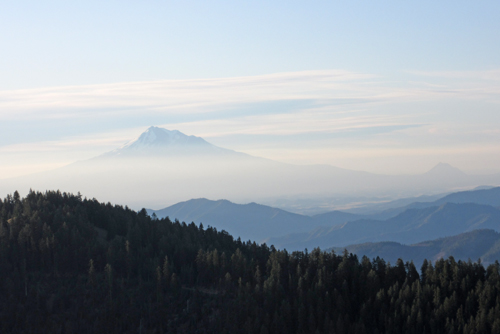
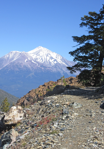
bikers. Mt. Shasta was in full view from the camp site and provided
a beautiful sunset. Mark
dropped my off at the trail-head as it emerges from under I-5 at
Highway mile six heading south. It's 8.5 miles up to the Mt. Ashland
Ski area, and Mark would set up camp at a FS campground, just off
the PCT. I slack packed (went with only a day pack) up the trail
to where he was camped, arriving around 1:00 pm on a Friday afternoon.
As the evening progressed, cars and trucks arrived with mountain
bikers. Mt. Shasta was in full view from the camp site and provided
a beautiful sunset.
I took off the next morning with full pack, scheduled
to meet up with Mark 5 days later in Seiad, CA. About 2 miles down
the trail I noticed strips of surveyor tape marking the trail. My
initial thought was that there was going to be a mountain bike event,
but it didn't seem possible since bikes are not allowed on the PCT.
When I broke for lunch I talked with a day hiker. She mentioned
that the flags were for a long distance trail run that probably
wouldn't be along until later in the day. My camp that night was
off the trail on a dead-end road close to a water source. I noticed
that the trail run flags came down the road then before reaching
my camp turned onto the PCT. In the middle of the night I started
hearing runners, and twice runners missed the turn onto the trail
and ended up running up to my tent, I heard "what the hell",
before realizing their error. And around 2:00 am a lone male runner
ran past my tent and a few minutes later came running back. I called
out to him that he missed the turnoff and that it was just on the
other side of the stream. I could tell he was exhausted, but he
thanked me for helping him out.
 The
next morning started out nice, but by mid-day, clouds were rolling
overhead. I stopped about 2:00 pm for water and met 3 hikers, one
headed north and the other two south. I got a weather forecast from
them, rain the next 5 days! I continued another two miles when I
noticed smoke rising from a fire two valleys to the west. Not long
after several UFS trucks rushed past on the road below the trail.
The wind had picked up, it had started to rain and when the trail
was in the open the rain was coming at me sideways. The rain lessen
my concerns about the fire so I decided to make camp sooner than
planned and looked for a spot somewhere out of the rain. All my
outer gear was wet, but I managed to get my tent set up and everything
stowed inside with minimal moisture. It poured all night but had
stopped by morning. I hate packing up a wet tent! The
next morning started out nice, but by mid-day, clouds were rolling
overhead. I stopped about 2:00 pm for water and met 3 hikers, one
headed north and the other two south. I got a weather forecast from
them, rain the next 5 days! I continued another two miles when I
noticed smoke rising from a fire two valleys to the west. Not long
after several UFS trucks rushed past on the road below the trail.
The wind had picked up, it had started to rain and when the trail
was in the open the rain was coming at me sideways. The rain lessen
my concerns about the fire so I decided to make camp sooner than
planned and looked for a spot somewhere out of the rain. All my
outer gear was wet, but I managed to get my tent set up and everything
stowed inside with minimal moisture. It poured all night but had
stopped by morning. I hate packing up a wet tent!
 My
day started out in a cloud with periodic light rain. A few hours
along the trail I met a couple heading north who told me of a road
I could take into Seiad, cutting off 2 miles of trail. The weather
forecast wasn't good and the last 5 miles of trail into Seiad was
overgrown with poison oak and blackberries. I filed that info, something
to think about for the next couple of hours. When I arrived at the
road junction I met up with the two young male hikers I had met
the day before. They had continued to hike through the rain until
making camp about 7 pm. They were only just packing up and getting
ready to leave. I was still unsure about whether I would take the
road or continue on the trail and had told them what I was considering.
After an hour of indecision I decided on the road, another 10 miles
into Seiad. I had already hiked about 9 miles that day and hoped
that if I decided not to go all the way, that I'd find a place to
camp for the night. My
day started out in a cloud with periodic light rain. A few hours
along the trail I met a couple heading north who told me of a road
I could take into Seiad, cutting off 2 miles of trail. The weather
forecast wasn't good and the last 5 miles of trail into Seiad was
overgrown with poison oak and blackberries. I filed that info, something
to think about for the next couple of hours. When I arrived at the
road junction I met up with the two young male hikers I had met
the day before. They had continued to hike through the rain until
making camp about 7 pm. They were only just packing up and getting
ready to leave. I was still unsure about whether I would take the
road or continue on the trail and had told them what I was considering.
After an hour of indecision I decided on the road, another 10 miles
into Seiad. I had already hiked about 9 miles that day and hoped
that if I decided not to go all the way, that I'd find a place to
camp for the night.
 My
knees had been bothering me and one advantage of the road (graded)
was that it was a gradual downhill hike. I passed one possible camp
spot, and then another. No cars had passed by. I estimated that
I was 2 miles from Seiad when the two young hikers passed me, having
liked my plan. I was quickly running out of steam when an older
lady drove past me in the opposite direction. Not long after I head
a car coming from behind and noticed it was the same car returning.
As the car approached it slowed down and the driver hadn't even
opened the window all the way when I said "yes". She had
come back to offer me a ride, just in time! I was a day early, had
no cell connection (Seiad has little or no cell coverage) to contact
Mark, who also, it turned out, had no cell coverage. I had my ride
drop me at the Wildwood Tavern run by a Trail Angel that afforded
a place to camp, a shower, washer/dryer, coffee and a big muffin
for breakfast for $20. My
knees had been bothering me and one advantage of the road (graded)
was that it was a gradual downhill hike. I passed one possible camp
spot, and then another. No cars had passed by. I estimated that
I was 2 miles from Seiad when the two young hikers passed me, having
liked my plan. I was quickly running out of steam when an older
lady drove past me in the opposite direction. Not long after I head
a car coming from behind and noticed it was the same car returning.
As the car approached it slowed down and the driver hadn't even
opened the window all the way when I said "yes". She had
come back to offer me a ride, just in time! I was a day early, had
no cell connection (Seiad has little or no cell coverage) to contact
Mark, who also, it turned out, had no cell coverage. I had my ride
drop me at the Wildwood Tavern run by a Trail Angel that afforded
a place to camp, a shower, washer/dryer, coffee and a big muffin
for breakfast for $20.
The forecast for the next couple of days was not
good. I had been hearing about the first 10 trail miles out of Seiad
first from trail journals, and then from first hand accounts from
hikers I met weeks before in Washington. The trail was extremely
overgrown, again with poison oak and blackberries, making the trail
and the numerous blown down trees hard to see and navigate. I heard
that a lot of the trees had been cut but the brush was still thick.
I made the decision to have Mark drive me to Etna, bypassing 56
miles of trail.
 It
turned out to be a good decision as the storm that blew in brought
with it lots of rain and cold temperatures. I met hikers who had
been caught in it, and did not fair well. Their old tents leaked,
and when they woke up in the morning there was an inch of water
in their tents, and everything wet. I spent two nights in the Etna
Motel, giving my knees a break, staying warm and making sure all
my gear was dry. Then Mark drove me up to Etna Pass, where I continued
south on the trail. It was 98.5 miles to Castle Crags. It
turned out to be a good decision as the storm that blew in brought
with it lots of rain and cold temperatures. I met hikers who had
been caught in it, and did not fair well. Their old tents leaked,
and when they woke up in the morning there was an inch of water
in their tents, and everything wet. I spent two nights in the Etna
Motel, giving my knees a break, staying warm and making sure all
my gear was dry. Then Mark drove me up to Etna Pass, where I continued
south on the trail. It was 98.5 miles to Castle Crags.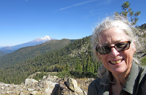
Mark would rendezvous with me two more times,
allowing me to carry less weight in food. One was a overnight where
he made me grilled tuna for dinner and a great breakfast before
I headed out, and the second time, a touch and go, he had a nice
lunch waiting.
Hunting season had started and I was thankful
for my pack's bright orange rain cover. For the first time while
hiking I actually heard gunshots!
Last year during late September and early October,
I encountered only 3 PCT hikers on the trail. This year, due to
hikers jumping forward, reversing directions and the number of SoBos
(thru hikers starting at the Canadian Border and hiking south) I
encountered 27 PCT hikers, 7 of whom were seniors, and an REI group
of 15 hikers.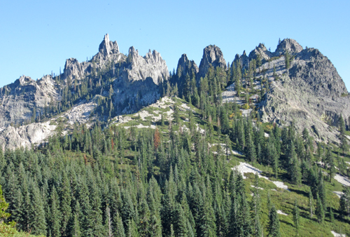
The weather the final eight days of the hike,
except for one night of rain, were sunny, with temperatures of 40º
F at night and 60's during the day. Views were dominated by Mt Shasta,
some with Mt. Lassen in the background, and the last two days views
of Castle Crags. It was a nice end to my hiking season. And after
2 failed attempts to finish this section, I was glad to finally
get it done, well almost.
My only regret was not completely finishing the
PCT and having to return once more next year to hike the 56 miles
between Etna and Seiad!
|
