|
 This
season's section hike of the Pacific Crest Trail would start at
Willamette Pass, Oregon, where my September 2013 section hike ended.
Once again Cheryl, who had been a great help to me in 2013, picked
me up at the Eugene train station and drove me to the pass to begin
the hike. By noon I was on the trail, eager to complete this section
and finally have fully completed the entire length of the PCT as
it runs the entire length of one state. This
season's section hike of the Pacific Crest Trail would start at
Willamette Pass, Oregon, where my September 2013 section hike ended.
Once again Cheryl, who had been a great help to me in 2013, picked
me up at the Eugene train station and drove me to the pass to begin
the hike. By noon I was on the trail, eager to complete this section
and finally have fully completed the entire length of the PCT as
it runs the entire length of one state.
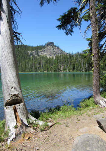
 The
first 50 miles of trail wound through forest interspersed with many
lakes and ponds. Because of this abundance of water, the PCT in
Oregon is notorious for its mosquitoes. The first hiker I encountered
was a woman who had started at the Columbia River. She was frustrated
with the army of mosquitoes she'd been battling for the past week.
My first night's camp was away from any water and relatively free
of the pest. But the second night's camp was on Charlton Lake and
as the evening approached the mosquitoes began appearing from their
hiding places. Nothing is worst than trying to pee and keep mosquitoes
off your butt! As soon as I had the tent up, and had eaten my dinner,
I popped into my tent and watched the buzzing Vampires hanging on
to the netting, wanting to get in to suck my blood! The
first 50 miles of trail wound through forest interspersed with many
lakes and ponds. Because of this abundance of water, the PCT in
Oregon is notorious for its mosquitoes. The first hiker I encountered
was a woman who had started at the Columbia River. She was frustrated
with the army of mosquitoes she'd been battling for the past week.
My first night's camp was away from any water and relatively free
of the pest. But the second night's camp was on Charlton Lake and
as the evening approached the mosquitoes began appearing from their
hiding places. Nothing is worst than trying to pee and keep mosquitoes
off your butt! As soon as I had the tent up, and had eaten my dinner,
I popped into my tent and watched the buzzing Vampires hanging on
to the netting, wanting to get in to suck my blood!
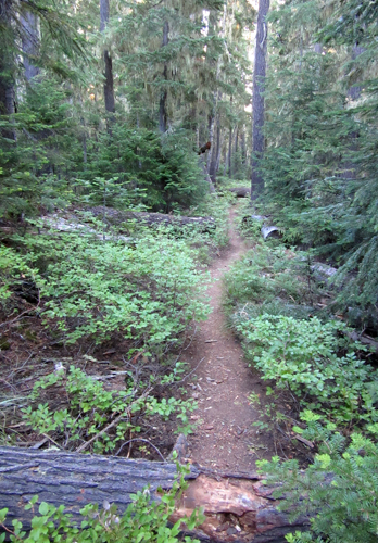 I
was up at 4:30 am the next day. Even before it was light the mosquitoes
began to reappear. It was non-stop swatting as I hiked down the
trail, stopping for breaks only rarely. As the day went on the mosquitoes
seemed to become fewer in number and I was able to find a camp that
evening in an open area, away from water, and mostly free of the
pest. As the days passed the tormentors became fewer and fewer,
indicating the end to their season. I thought about the woman I
met on the first day, feeling lucky to have had only a few days
of misery in the mosquito battle. I
was up at 4:30 am the next day. Even before it was light the mosquitoes
began to reappear. It was non-stop swatting as I hiked down the
trail, stopping for breaks only rarely. As the day went on the mosquitoes
seemed to become fewer in number and I was able to find a camp that
evening in an open area, away from water, and mostly free of the
pest. As the days passed the tormentors became fewer and fewer,
indicating the end to their season. I thought about the woman I
met on the first day, feeling lucky to have had only a few days
of misery in the mosquito battle.
 Most
of the thru-hikers complete the transit of Oregon by August. Everyday
5-10 hikers passed me, all, by now, doing 20-30 miles a day, the
Canadian border clearly in their sights. Each year thru-hikers face
challenges to overcome such as drought, fire, and trail damage.
This year, in addition to a fire at Crater Lake that closed the
trail for a period of time, a section north of Mt. McLoughlin was
totally inundated with blown down trees. With each hiker I encountered
the number of trees kept increasing, 100, 199, over 200. Whatever
the number, it took several days to transit that part of the trail.
I met a young man heading to the area to head a work party responsible
for clearing the trail of trees. A week later I encountered a half-mile
section of trail completely covered with downed trees, and as I
climbed over and under each one, I felt fortunate it was only for
a short distance. I was pleased that I had completed the devastated
area in southern Oregon three years earli Most
of the thru-hikers complete the transit of Oregon by August. Everyday
5-10 hikers passed me, all, by now, doing 20-30 miles a day, the
Canadian border clearly in their sights. Each year thru-hikers face
challenges to overcome such as drought, fire, and trail damage.
This year, in addition to a fire at Crater Lake that closed the
trail for a period of time, a section north of Mt. McLoughlin was
totally inundated with blown down trees. With each hiker I encountered
the number of trees kept increasing, 100, 199, over 200. Whatever
the number, it took several days to transit that part of the trail.
I met a young man heading to the area to head a work party responsible
for clearing the trail of trees. A week later I encountered a half-mile
section of trail completely covered with downed trees, and as I
climbed over and under each one, I felt fortunate it was only for
a short distance. I was pleased that I had completed the devastated
area in southern Oregon three years earli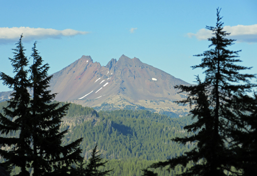 er. er.
In August 2015 I encountered many PCT south bound
hikers (SoBos) between Carson Pass and Lake Tahoe in California,
more than 750 miles to the south. This year at the same time, the
SoBos were only transiting Oregon. The years 2014 and 2015 were
both drought years, and SoBos were able to leave the north terminus
earlier due to the lack of snow. This year, however, SoBos were
leaving at the more traditional time in early July.
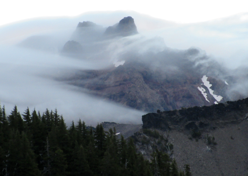
The fourth night's campsite
was atop a ridge overlooking Mt. Bachelor and Mt. Broken Top, the
southern edge of the Three Sisters Wilderness, at the beginning
of the Oregon Cascade volcanics. The Cascades are a volcanic arc
of stratovolcanoes, formed around 1.6 million years ago, and part
of a range stretching over 700 miles from British Columbia, Canada,
south to Northern California. Within the range is a string of 13
main volcanic centers and thousands of small transitory volcanoes
that have produced raised areas of volcanic debris and lava.
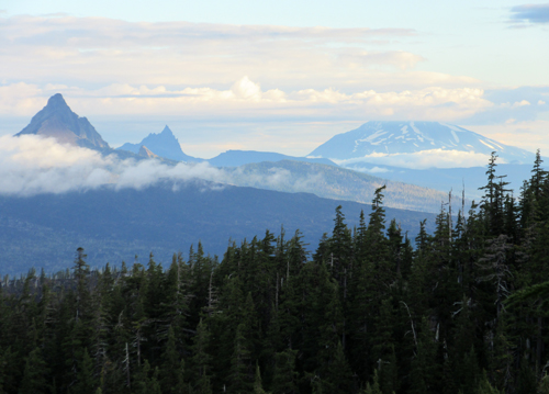
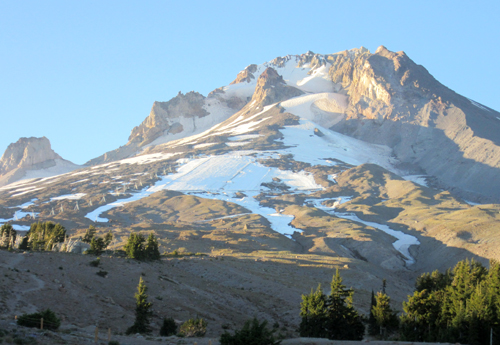
 The
Three Sisters Wilderness Area volcanics begin at Broken Top (9,175
feet) and is dominated by South Sister (10,358 feet), Middle Sister
(10,047 feet), and North Sister (10,085 feet). The high, snowcapped
Three Sisters contain 14 glaciers offering perhaps the best example
of the effects of glaciation in the Pacific Northwest. The
Three Sisters Wilderness Area volcanics begin at Broken Top (9,175
feet) and is dominated by South Sister (10,358 feet), Middle Sister
(10,047 feet), and North Sister (10,085 feet). The high, snowcapped
Three Sisters contain 14 glaciers offering perhaps the best example
of the effects of glaciation in the Pacific Northwest.
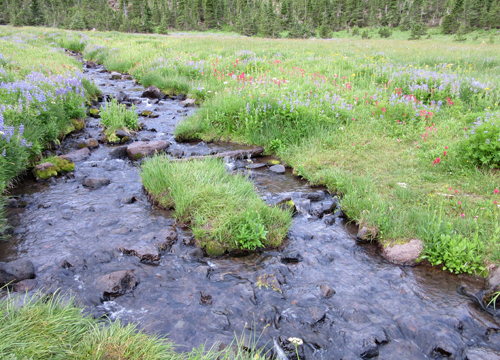
It was nice to be out of the forest, hiking under
volcanic peaks, and through meadows full of wild flowers. Being
a weekend, many of the hikers I encountered were doing the approximate
50 mile circuit around the Sisters. As I've hiked and experienced
different sections of the PCT an inventory of potential future hikes
is being noted, especially in areas so close to home.
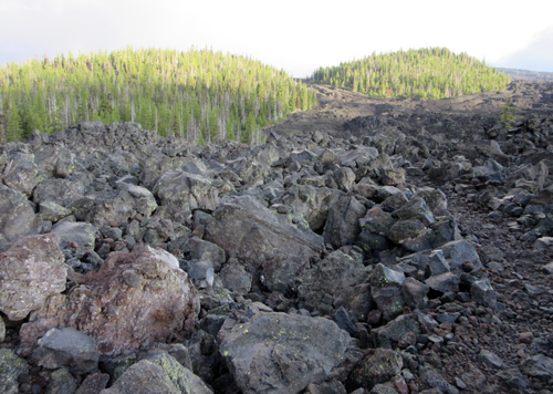
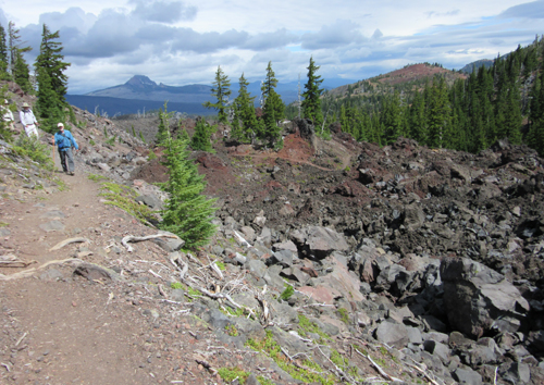
 North
of the Three Sisters Wilderness Area, at McKenzie Pass, the trail
enters a vast area of lava flows where the footing becomes more
difficult as it climbs through the lava field. I took my time, being
very careful of my footing, not wanting to stumble and fall in the
abrasive rocks. When finally out of the lava, the trail improved,
and I could pick up my pace. About five miles from that night's
destination and my re-supply, a Seventh-Day Adventist summer camp,
bam! I was face down on the trail. My nose and lip were bleeding
as I got out of my pack, rinsed my face, and rummaged my pack for
the "first aid" kit. The bleeding was finally gotten under
control and band-aids applied, all without a mirror. Once on the
trail I noticed that I had also banged my left knee but it didn't
affect my ability to hike. North
of the Three Sisters Wilderness Area, at McKenzie Pass, the trail
enters a vast area of lava flows where the footing becomes more
difficult as it climbs through the lava field. I took my time, being
very careful of my footing, not wanting to stumble and fall in the
abrasive rocks. When finally out of the lava, the trail improved,
and I could pick up my pace. About five miles from that night's
destination and my re-supply, a Seventh-Day Adventist summer camp,
bam! I was face down on the trail. My nose and lip were bleeding
as I got out of my pack, rinsed my face, and rummaged my pack for
the "first aid" kit. The bleeding was finally gotten under
control and band-aids applied, all without a mirror. Once on the
trail I noticed that I had also banged my left knee but it didn't
affect my ability to hike.
 Santiam
Pass divides the Mt. Washington Wilderness from the Mt. Jefferson
Wilderness. While the pass was known by native peoples, the first
recorded crossing of the pass was in April 1859 by an expedition
searching for a cattle trail over the Cascade Range from the Willamette
Valley to Central Oregon. The opening of the pass in 1861 with the
Santiam Wagon Road facilitated settlement and cattle ranching in
the grasslands east of the Cascades. Santiam
Pass divides the Mt. Washington Wilderness from the Mt. Jefferson
Wilderness. While the pass was known by native peoples, the first
recorded crossing of the pass was in April 1859 by an expedition
searching for a cattle trail over the Cascade Range from the Willamette
Valley to Central Oregon. The opening of the pass in 1861 with the
Santiam Wagon Road facilitated settlement and cattle ranching in
the grasslands east of the Cascades.
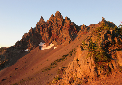 Forty
miles of the PCT pass through the Jefferson Wilderness beginning
with Three Fingered Jack (7,841 feet) as the southern boundary,
with Mt. Jefferson (10,497 feet), the 2nd highest mountain in Oregon,
and Jefferson Park marking the northern extent. Another 60 miles
and I arrived at Timberline Lodge on the flank of Mt. Hood. For
two weeks I had been hearing of the Lodge's famous buffet breakfast,
said not to be missed. I set up camp close to the Lodge with a great
view of Mt. Hood under a full moon, with thoughts of breakfast. Forty
miles of the PCT pass through the Jefferson Wilderness beginning
with Three Fingered Jack (7,841 feet) as the southern boundary,
with Mt. Jefferson (10,497 feet), the 2nd highest mountain in Oregon,
and Jefferson Park marking the northern extent. Another 60 miles
and I arrived at Timberline Lodge on the flank of Mt. Hood. For
two weeks I had been hearing of the Lodge's famous buffet breakfast,
said not to be missed. I set up camp close to the Lodge with a great
view of Mt. Hood under a full moon, with thoughts of breakfast.
 The
wind began blowing by 10:00 pm and kept increasing through the night.
About 1:00 am one of the tent stakes came out, weakening the stability
of my hiking poles that are used to hold up the tent. I held the
poles in place, and when there was a lull in the wind ran outside
to secure the stake. About an hour later I could feel the tent collapse
on me and realized that the critical stake had come out. Now I had
no choice but hold up the poles and once again run out during a
lull to secure that stake. I was not going to get to sleep again
so at 4:30 am packed up and went to the lodge, which didn't open
until 6:00 am. At this point the buffet breakfast, which didn't
start until 9:00 am, was not important. I had left my camera charging
in the lodge the night before and as soon as I could get inside
and retrieve my camera, I returned to the trail. The
wind began blowing by 10:00 pm and kept increasing through the night.
About 1:00 am one of the tent stakes came out, weakening the stability
of my hiking poles that are used to hold up the tent. I held the
poles in place, and when there was a lull in the wind ran outside
to secure the stake. About an hour later I could feel the tent collapse
on me and realized that the critical stake had come out. Now I had
no choice but hold up the poles and once again run out during a
lull to secure that stake. I was not going to get to sleep again
so at 4:30 am packed up and went to the lodge, which didn't open
until 6:00 am. At this point the buffet breakfast, which didn't
start until 9:00 am, was not important. I had left my camera charging
in the lodge the night before and as soon as I could get inside
and retrieve my camera, I returned to the trail.
 My
camera is a Canon "point and shoot". I had a problem charging
the battery the summer before and thought it was just a fluke when
the charge only lasted a day. But after attempting to re-charge
the battery on this hike three times, I now know that it can't be
done at a facility that uses a generator for power. I've talked
it over with people much smarter than I; it's a puzzle to everyone.
The battery doesn't take a complete charge and I'm left with less
than 10 pictures before it's dead. So once again there are big gaps
in my pictorial record. I now know to only re-charge that battery
with regulated power. My
camera is a Canon "point and shoot". I had a problem charging
the battery the summer before and thought it was just a fluke when
the charge only lasted a day. But after attempting to re-charge
the battery on this hike three times, I now know that it can't be
done at a facility that uses a generator for power. I've talked
it over with people much smarter than I; it's a puzzle to everyone.
The battery doesn't take a complete charge and I'm left with less
than 10 pictures before it's dead. So once again there are big gaps
in my pictorial record. I now know to only re-charge that battery
with regulated power.
Timberline was only three days hike to the Columbia
River, the end of this season's hike. My plan was to reach the Bridge
of the Gods, on the Columbia River by Saturday, August 20th. A festival
known as PCT Days was being held that weekend and I was hoping to
find a ride into Portland without having to hitch-hike out on the
highway. Also, several hikers that I had met over the last two weeks
were planning on getting off the trail to attend.
 The
PCT association hosts two events during the hiking season, "Kick
Off" at the end of April at Lake Moreno, 20 miles from the
Mexican border, and "PCT Days" in late August on the Oregon
side at Bridge of the Gods. Both events feature the latest outdoor
recreation gear from exhibiting sponsors, raffles of great products,
food and beverages, and fun activities. Camping and showers were
available. The
PCT association hosts two events during the hiking season, "Kick
Off" at the end of April at Lake Moreno, 20 miles from the
Mexican border, and "PCT Days" in late August on the Oregon
side at Bridge of the Gods. Both events feature the latest outdoor
recreation gear from exhibiting sponsors, raffles of great products,
food and beverages, and fun activities. Camping and showers were
available.
I arrived Saturday afternoon and immediately began
to run into hikers I had met earlier on the trail, including one
woman I had met only three days earlier. On the trail I had talked
with her for less than five minutes, yet when we met at "PCT
Days" it was like we were long-lost friends. There were several
hikers I had met at the summer camp after my accident who were seeing
me for the first time looking semi normal. It was fun. My main goal
was to try to find a ride to Portland, but by Sunday morning I still
hadn't secured one. So I stood at the exit to the park where the
event was being held and after about 15 minutes got a ride with
a great guy all the way into Portland. Thank you Brian.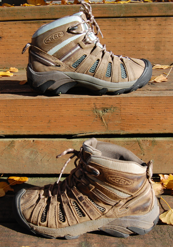
After 1100 miles I'm retiring
my Keen boots and bringing out their replacement. Once I knew that
the origiinal boots were winners I immediately bought the same boot
and have had them waiting patiently in their box. They will make
their debut fall 2017 on my next section hike.
Except for 18 miles from Ashland to the California/Oregon
border I've now finished the trail as it runs through state of Oregon.
I have 540 miles from Donner Pass to the CA/OR border to complete,
as well as 366 miles from White Pass to the Canadian border in Washington.
Three more seasons and I will have completed the PCT. Hard to believe
I've stuck to the plan of completing the trail by the time I'm 70
years old!
|
