|
I turned 70 years old at the end of April and
I was hoping to complete my Pacific Crest Trail journey during this
season.
My plan for the 2019 hiking season was to consist
of three non-consecutive sections, totaling 377 miles. I began the
first section the first week of August, departing from White Pass
bound for Snoqualmie Pass in Washington, a total of 98.3 miles.
White Pass to Snoqualmie
Pass
 Once
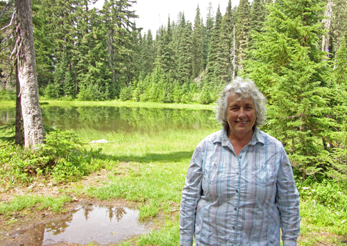
again, I was able to get a ride to White Pass from my friend Peggy.
It was raining during most of the drive, but when we arrived at
White Pass at 11:00 am the sun had come out. As we walked to the
trail-head, we met a PCT hiker from the Netherlands who I thought
I might run into again when I hiked from Rainy Pass to the Canadian
Border. Peggy hiked with me for a couple of hours before returning
to her car. Thank you Peggy! Soon after it again began to rain and
it would remain wet for the next 2 days and nights. By the time
I got to Chinook Pass, the sun was out again and stayed out the
rest of this section. Once
again, I was able to get a ride to White Pass from my friend Peggy.
It was raining during most of the drive, but when we arrived at
White Pass at 11:00 am the sun had come out. As we walked to the
trail-head, we met a PCT hiker from the Netherlands who I thought
I might run into again when I hiked from Rainy Pass to the Canadian
Border. Peggy hiked with me for a couple of hours before returning
to her car. Thank you Peggy! Soon after it again began to rain and
it would remain wet for the next 2 days and nights. By the time
I got to Chinook Pass, the sun was out again and stayed out the
rest of this section.
 I
encounter PCT thru hikers every day and learned their challenges
for the 2019 season. The snowfall in the Sierras was heavy last
winter, and there were several late storms well into May. I spoke
with several hikers who had started in the Sierras in May but after
crossing Forrester Pass, the southern-most and highest pass in the
Sierras, they had realized that it was very dangerous, didn't feel
comfortable continuing, and exited at Kersage Pass. I
encounter PCT thru hikers every day and learned their challenges
for the 2019 season. The snowfall in the Sierras was heavy last
winter, and there were several late storms well into May. I spoke
with several hikers who had started in the Sierras in May but after
crossing Forrester Pass, the southern-most and highest pass in the
Sierras, they had realized that it was very dangerous, didn't feel
comfortable continuing, and exited at Kersage Pass.
Most of the thru hikers exited the trail at Kennedy
Meadows, the southern entrance into the Sierras. Since the snow
was also heavy north of Donner Pass into June, most hikers were
jumping up to Chester, CA, just south of Mt. Lassen, and then continuing
north. Once they got to the Canadian Border their plan was to return
to Chester and hike south through the Sierras. Some hikers would
just get off at Kennedy Meadows, make their way to Hart's Pass,
30 miles from the Canadian Border, hike to the Canadian Border then
turn around and hike south through Washington, Oregon, northern
California and the Sierras, ending at Kennedy Meadows. The options
of the best strategy were numerous and yes, it was complicated.
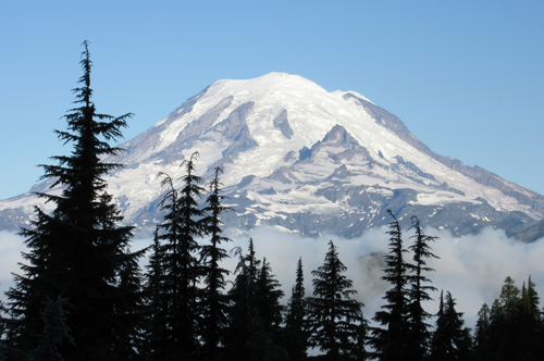 I
awoke on the third day to sunshine. Soon after hitting the trail
I got my first view of Mt Rainier, which would dominate the skyline
for the next couple of days. I crossed Chinook Pass the same day,
hiked up to Sheep Lake, a popular spot 2 miles from the highway,
and continued on hoping to find a good camp site in the next few
miles. It was getting on to 5:00 pm when I came across a small campsite
occupied by two older couples from Washington. They offered to share
the site, small as it was, and I opted to stay. Having spent the
last 2 nights in the rain, it was good to have the opportunity to
dry out my tent plus having company to enjoy for the evening. The
next morning I left camp before they were awake. I
awoke on the third day to sunshine. Soon after hitting the trail
I got my first view of Mt Rainier, which would dominate the skyline
for the next couple of days. I crossed Chinook Pass the same day,
hiked up to Sheep Lake, a popular spot 2 miles from the highway,
and continued on hoping to find a good camp site in the next few
miles. It was getting on to 5:00 pm when I came across a small campsite
occupied by two older couples from Washington. They offered to share
the site, small as it was, and I opted to stay. Having spent the
last 2 nights in the rain, it was good to have the opportunity to
dry out my tent plus having company to enjoy for the evening. The
next morning I left camp before they were awake.
Later in the morning as I was hiking above the
Crystal Mt. ski area, I met four mid-aged hikers, one of whom was
handing out trail magic, chips and candy pieces popular with hikers.
Something about him seemed familiar, and then I remembered encountering
him and his daughter last year just north of Snoqualmie Pass. At
that time he was also carrying and handing out trail magic. Once
I mentioned our previous encounter he remembered me.
 As
I hiked and met other PCT hikers, I once again wondered if I would
meet any of them again when I hiked the section Rainy Pass to the
Canadian Border. As
I hiked and met other PCT hikers, I once again wondered if I would
meet any of them again when I hiked the section Rainy Pass to the
Canadian Border.
The afternoon before I arrived at Snoqualmie Pass,
I met two young male SoBo (southbound) thru hikers. When I asked
where they were from one said the Falklands. I've been to the Falklands
while cruising on our sailboat 11 years earlier, and everyone on
the islands know each other. So I started mentioning various people
I had met and, of course, he knew them, and gave me an update. His
companion just stood there, his mouth open. They had been hiking
together since Harts Pass and not one hiker knew where the Falklands
were, let alone been there. And along comes a senior hiker who had
not only been to the Falklands, but had mutual acquaintances!
 I
had tried, unsuccessfully, before I left, to find a ride from Snoqualmie
Pass to at least downtown Seattle. Luckily there is a weekend hiker
bus from North Bend, 20 miles west of Snoqualmie Pass, to downtown,
where I could catch the ferry to Bainbridge, then the bus connections
on to Port Townsend. I had to reach Snoqualmie by Friday afternoon,
as Saturday was the only day all modes of transportation coordinated
all the way home. I
had tried, unsuccessfully, before I left, to find a ride from Snoqualmie
Pass to at least downtown Seattle. Luckily there is a weekend hiker
bus from North Bend, 20 miles west of Snoqualmie Pass, to downtown,
where I could catch the ferry to Bainbridge, then the bus connections
on to Port Townsend. I had to reach Snoqualmie by Friday afternoon,
as Saturday was the only day all modes of transportation coordinated
all the way home.
The last 3 days I had to stay on track, hiking
16 miles each day in order to reach Snoqualmie on Friday. After
an overnight at the Summit Inn at Snoqualmie Pass, I went to the
gas station next door and approached drivers until a couple who
lived in North Bend gave me a ride. I was then able to make all
my connections and arrive home in Port Townsend by 5:30 pm.
Rainy Pass to the Canadian Border and Return
to Harts Pass
Four days after completing the section from White
Pass to Snoqualmie Pass I was ready for the hike from Rainy Pass
to the Canadian Border. I had a decision to make: 1) find a ride
to Rainy Pass, hike into Manning Park, 10 miles over the Canadian
Border, then find a ride back to Port Townsend; 2) leave my car
at Rainy Pass, hike to the border, turn around and hike 30 miles
back to Harts Pass, and hitchhike back to Rainy Pass. In the end
I decided on option 2 and drove myself to Rainy Pass. The only unknown
would be how to get from Harts Pass back to my car.
 In
2018 I had planned to finish Northern California, allowing me complete
the PCT in 2019 with the hike from White Pass to the Canadian Border.
However, the 2018 fires in Northern California forced me to cancel
finishing California, re-think and change my plans. The smoke from
BC and Washington fires delayed my departure into the Cascades,
and I was unable to even finish Washington state. This left three
non-consecutive sections for 2019. In
2018 I had planned to finish Northern California, allowing me complete
the PCT in 2019 with the hike from White Pass to the Canadian Border.
However, the 2018 fires in Northern California forced me to cancel
finishing California, re-think and change my plans. The smoke from
BC and Washington fires delayed my departure into the Cascades,
and I was unable to even finish Washington state. This left three
non-consecutive sections for 2019.
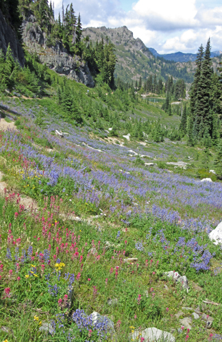
It was a beautiful day as I took the ferry from
Port Townsend to Whidbey Island, drove up to Rainy Pass and found
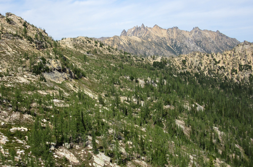
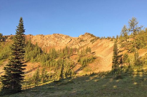
myself back on the trail by 11:30 am. Cutthroat Pass is 5 miles
and a 2,000 foot climb from Rainy Pass, where the views of the North
Cascades are spectacular. I was surprised at the number of senior
day hikers on the trail, though I shouldn't have been since it was
mid-August, the peak hiking season. I encountered my first PCT hikers
about a mile from that's night camp. My friend and neighbor Rosemary
had given me a small bag of figs from her yard. I had left some
in a paper bag at the trail-head, and that night in camp I heard
a hiker taking about the great figs she found earlier in the day.
Trail magic!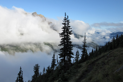
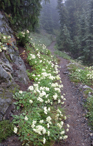
The weather forecast for
the next day was for rain in the afternoon, but even though it started
as a beautiful morning, by 9:30 am it had started to rain lightly
and would do so all day. Most of the day was spent in the woods
along the West Fork Methow River, but as the trail climbed up to
Glacier Pass the brush became thick and heavy with rain, making
for a very wet climb. I had met a couple from North Carolina earlier
in the day, trail names Mountain Goat and Hip Bone, and we camped
at the Pass that night. By 6:00 pm another 10 people had made camp
in the same area. It was August 21st and the PCT hiker push for
Canada was in full force.
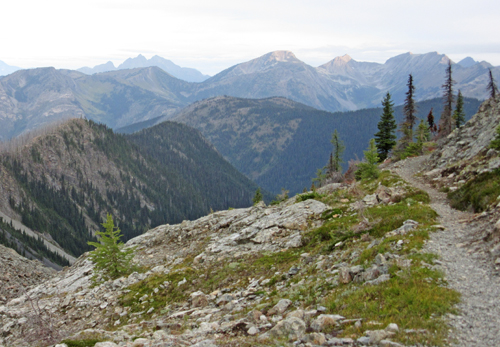
The weather pattern for the rest of the hike was
one day clear and beautiful, then one day of rain. I was lucky in
that on the return from the Canadian border to Harts Pass (30 miles),
I would have clear days on the portions of trail I had rain on the
way north, allowing me to get the views I had missed earlier.
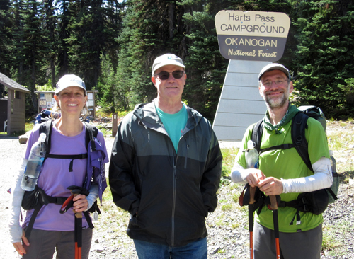 I
arrived at Harts Pass mid-day on day 3 and was met by Mountain Goat
and Hip Bone as well as about 8 other hikers. And there to greet
us all was, trail angel Magic Man, well known in Washington, his
car full of treats and a cooler full of drinks. His daughter had
been hiking the PCT the last 10 years and was due the next day on
her final leg. I spent about a hour talking with Magic Man and discovered
he grew up in Dockton on Vashon Island down the street from where
I lived for 10 years, 30 years ago. It also became apparent that
it would not be a problem hitching a ride from Harts Pass down to
Hwy 20 and on to my car at Rainy Pass. I
arrived at Harts Pass mid-day on day 3 and was met by Mountain Goat
and Hip Bone as well as about 8 other hikers. And there to greet
us all was, trail angel Magic Man, well known in Washington, his
car full of treats and a cooler full of drinks. His daughter had
been hiking the PCT the last 10 years and was due the next day on
her final leg. I spent about a hour talking with Magic Man and discovered
he grew up in Dockton on Vashon Island down the street from where
I lived for 10 years, 30 years ago. It also became apparent that
it would not be a problem hitching a ride from Harts Pass down to
Hwy 20 and on to my car at Rainy Pass.
It would take two more days to hike to the Canadian
Border. Along the way I met many PCT hikers, and it was about 50/50
on those continuing into Canada, versus those returning to Harts
Pass. I was about four miles from the Border when a hiker passed
me and we paused to talk. I realized that he was the hiker from
the Netherlands I had met at White Pass two week prior. The next
day as I was hiking back to Harts Pass, I would meet a couple I
had met a few days south of Snoqualmie Pass. It didn't surprise
me that they'd catch up to me since they were hiking a very fast
pace!
 As
I approached the border, I encountered hikers I had met just a few
days before, returning from the border, and were now on their way
south. I was about a half mile from the border and as I approached
could hear a group of people at the border monument, but when I
arrived there was no one in sight. For years I had seen photos of
hikers at the monument and I was excited about finally arriving.
But there I was, on my own, and no one to share the moment. I took
the appropriate photo, had lunch and spent about a hour hanging
out, but no one showed up. I turned around to hike the 30 miles
back to Harts Pass. As
I approached the border, I encountered hikers I had met just a few
days before, returning from the border, and were now on their way
south. I was about a half mile from the border and as I approached
could hear a group of people at the border monument, but when I
arrived there was no one in sight. For years I had seen photos of
hikers at the monument and I was excited about finally arriving.
But there I was, on my own, and no one to share the moment. I took
the appropriate photo, had lunch and spent about a hour hanging
out, but no one showed up. I turned around to hike the 30 miles
back to Harts Pass.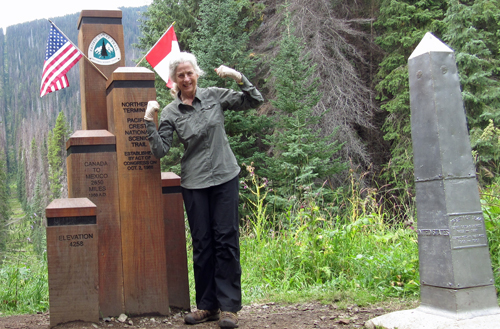
I was only 2 miles from the Border when I met
Julie and her dog Liz, from Whidbey Island, who was camped at Hopkins
Lake, where I also planned to camp that night. That evening we talked.
She offered me a ride from Harts Pass, where she had parked her
car, to Rainy Pass if I was there Monday by 11 am. It was Saturday
and Harts Pass was less 25 miles from Hopkins Lake.
 It
started raining about 5:00 am the next morning but I was on the
trail at 6:00 am wanting to get on the trail before Julie. I knew
she could hike faster and further than me. Between the rain and
the brush I was totally wet by 8:00 am, but after crossing Woody
Pass, the clouds lifted and the sun began to come out. There were
those views I had missed just the day before. I pushed myself really
hard, hiking 18.5 miles with 3 big climbs along the way. My goal
was to camp that night within 6 miles of Harts Pass so I could easily
meet Julie at 11:00 am. I had passed a message to Julie via hikers
going north to let her know where I intended to camp for the night.
She came into camp just 30 minutes after I arrived and she had left
3 hours after I had! Already camped in the same spot was a couple
I had met 2 days before and with whom Julie had camped with 2 nights
before. They were from Pennsylvania and spend a month each summer
hiking in the west, usually on trails less traveled. It
started raining about 5:00 am the next morning but I was on the
trail at 6:00 am wanting to get on the trail before Julie. I knew
she could hike faster and further than me. Between the rain and
the brush I was totally wet by 8:00 am, but after crossing Woody
Pass, the clouds lifted and the sun began to come out. There were
those views I had missed just the day before. I pushed myself really
hard, hiking 18.5 miles with 3 big climbs along the way. My goal
was to camp that night within 6 miles of Harts Pass so I could easily
meet Julie at 11:00 am. I had passed a message to Julie via hikers
going north to let her know where I intended to camp for the night.
She came into camp just 30 minutes after I arrived and she had left
3 hours after I had! Already camped in the same spot was a couple
I had met 2 days before and with whom Julie had camped with 2 nights
before. They were from Pennsylvania and spend a month each summer
hiking in the west, usually on trails less traveled.
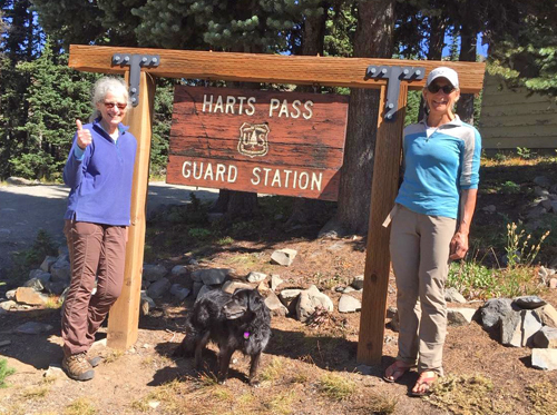 Once
again the next morning I was on my way before Julie, and I arrived
at Harts Pass by 11:00 am. I anticipated that Julie would catch
up and pass me along the way. But she had lingered with our camp-mates
longer than planned and showed up an hour later. Mission accomplished.
We drove down to Mazama at the junction with Hwy 20, had lunch,
and then she dropped me at my car. Thank you Julie! The day was
sunny and clear, the scenery absolutely beautiful, a great end to
my hike in the North Cascades. Once
again the next morning I was on my way before Julie, and I arrived
at Harts Pass by 11:00 am. I anticipated that Julie would catch
up and pass me along the way. But she had lingered with our camp-mates
longer than planned and showed up an hour later. Mission accomplished.
We drove down to Mazama at the junction with Hwy 20, had lunch,
and then she dropped me at my car. Thank you Julie! The day was
sunny and clear, the scenery absolutely beautiful, a great end to
my hike in the North Cascades.
A week after getting home I was on a plane to
Alaska to join Mark for the drive south to Port Townsend, a drive
we have done many times, yet it never ceases to amaze us both. Upon
arriving home we would do a 24 hour turn-around, and head south
for my final hike from Ashland, OR to Castle Crags, CA. Mark would
support me along the way.
|
